
LIVE
Nasdaq Plunges 5.5% as AI Stocks Sell Off After US Midterms  •  Spain Identifies 66 of 69 Victims of the Urda Train Crash, Including Four Americans  •  Israel Stuck in Election Deadlock as Bennett Backs Eisenkot — and No Bloc Reaches 61 Seats
World

Cyclone Murasu: Red Alert in Andhra Pradesh as Severe Storm Neared Landfall Near Ongole on 2 November

Trending Now • 2 November 2026 • 4 min read

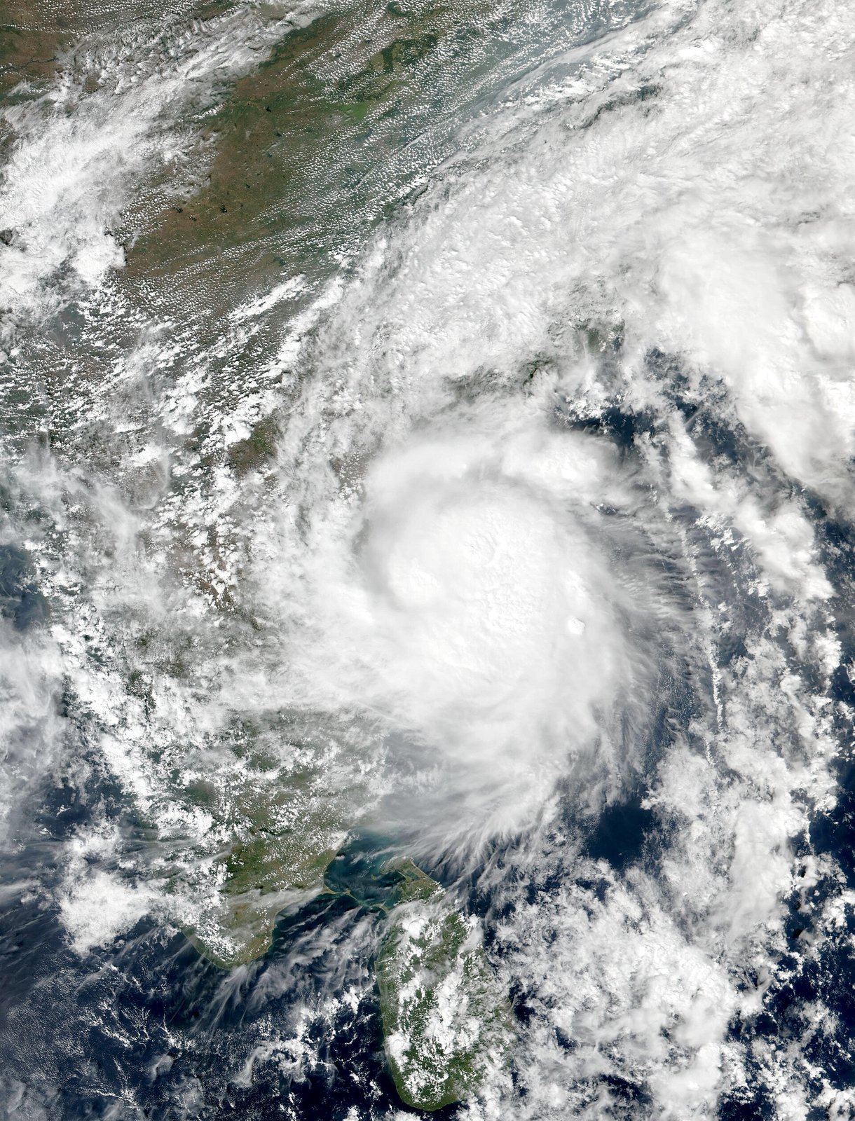
Cyclone Murasu near peak intensity off south-east India on 2 November 2026, the day it made landfall in Andhra Pradesh; Sri Lanka visible…

Photo: NOAA / Suomi-NPP VIIRS, public domain, via Wikimedia Commons.

TL;DR — the direct answer: Severe Cyclonic Storm Murasu is expected to cross the south Andhra Pradesh coast between Nellore and Narsapur, close to Ongole, between 11:30 pm on Monday 2 November and 4 am on Tuesday 3 November 2026, with sustained winds of 100 to 110 km/h gusting to 120 km/h. The India Meteorological Department (IMD) has issued a red-message cyclone warning for the Andhra Pradesh and adjoining north Tamil Nadu coasts, and authorities have begun evacuating low-lying coastal residents.

What happened: As of the IMD's 2:30 pm hourly update on 2 November, Murasu lay about 170 km southeast of Ongole, 110 km east-southeast of Nellore, 150 km north-northeast of Chennai and 190 km south-southeast of Bapatla, moving west-northwest at about 14 km/h over the past six hours. Earlier, at 2:30 am, it was centred near latitude 13.6°N and longitude 82.5°E, roughly 260 km east-northeast of Chennai and 290 km east-southeast of Nellore, and it had intensified into a severe cyclonic storm over the west-central and adjoining southwest Bay of Bengal. The forecast landfall window, repeated across IMD bulletins through the day, is 11:30 pm on 2 November to 4 am on 3 November, as a severe cyclonic storm.

Why it's trending: This is the second major Bay of Bengal system in about a week for Andhra Pradesh, coming days after Cyclone Arnab, which this site covered on 1 November. That recent experience is part of why the warnings are being taken seriously: red alerts today cover Krishna, Guntur, Bapatla, Prakasam and Nellore districts, with extremely heavy rain risk, while north Tamil Nadu and Puducherry face winds of 60 to 70 km/h gusting to 80 from the evening into Tuesday morning. A storm surge of 1.0 to 1.5 metres is forecast, rising to 1.5 to 2 metres above tide in later bulletins for low-lying south coastal Andhra, with the highest risk in Bapatla, Krishna and Prakasam districts. Chennai declared a school holiday for 2 November, Tiruvallur followed, and Odisha's Malkangiri closed schools and colleges from 2 to 4 November.

Background / context: A red message is the IMD's highest cyclone warning stage in its four-stage system, and it has been in place for these coasts since the 5:30 pm bulletin on 1 November. The state disaster machinery is correspondingly large: Andhra Pradesh has activated helplines 112, 1070 and 1800-425-0101 along with State Emergency Operations Centre numbers, and 12 National and State Disaster Response Force teams are positioned. Andhra Pradesh State Disaster Management Authority managing director Prakhar Jain told Reuters on Monday that about 2,000 residents had already been evacuated and about 30,000 people in total were planned to be moved. Fishermen are advised to stay off the southwest Bay until the morning of 4 November, and off the Andhra coast from the morning of 2 November to the afternoon of 4 November. Ports including Visakhapatnam, Kakinada, Gangavaram, Krishnapatnam, Machilipatnam, Nizampatnam and Vadarevu are under local cautionary signals.

What we know / what's unconfirmed: Confirmed, from IMD bulletins: the storm's position and movement through 2 November, the red warning, the forecast landfall window and wind speeds, the surge forecast, and the evacuation figures quoted by the state disaster authority. Not confirmed yet, because it has not happened: the exact landfall point, the actual surge height, and the extent of damage, flooding or power disruption. Forecasts are IMD projections, not events, and this post will need a follow-up once landfall occurs. Readers in affected districts should follow IMD and state authority updates, not this summary alone, for evacuation orders.

What happens next: Landfall is expected overnight, after which the system will weaken inland but continue to bring heavy to extremely heavy rain to Andhra Pradesh, Telangana, Odisha and Chhattisgarh on 3 November. Orange alerts are already in place for several districts on Tuesday, and a red alert for Alluri Sitarama Raju, Eluru and NTR districts on 3 November. The key updates to watch are the post-landfall IMD bulletin, the state government's damage and relief figures, and when schools, transport and power are restored.

Advertisement

Frequently asked questions

Q: When will Cyclone Murasu make landfall?
A: Between 11:30 pm on 2 November and 4 am on 3 November 2026, between Nellore and Narsapur, close to Ongole, according to IMD forecasts.

Q: How strong will the winds be?
A: Sustained winds of 100 to 110 km/h, gusting to 120 km/h at landfall, with a storm surge of 1 to 1.5 metres, possibly up to 2 metres above tide in low-lying areas.

Q: Which districts are on red alert?
A: Krishna, Guntur, Bapatla, Prakasam and Nellore on 2 November, with further red alerts for Alluri Sitarama Raju, Eluru and NTR on 3 November.

Sources: CareerIndia — Murasu landfall timing and red alerts • Transclew — Murasu live updates from IMD bulletins

← Back home